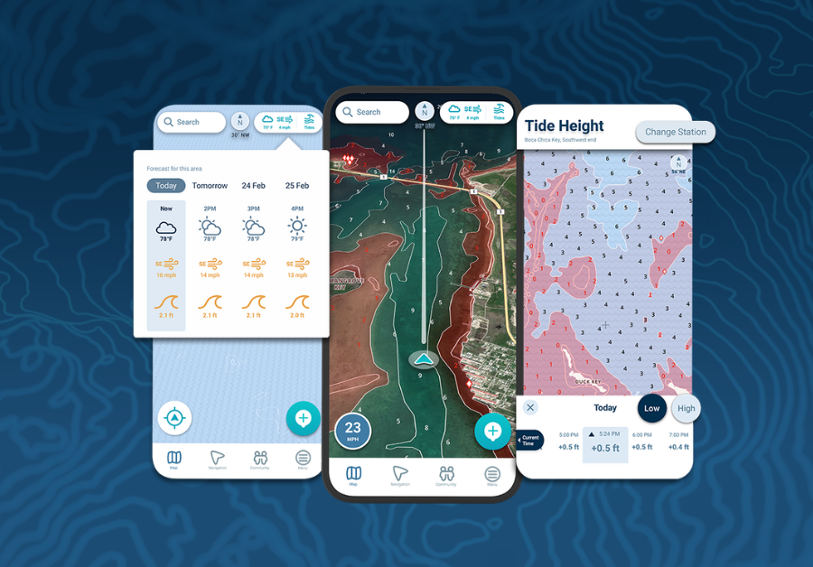
Choosing a marine navigation app is not simply about finding the lowest subscription price. Boaters also need to consider chart coverage, offline access, route planning, weather information, and whether advanced features are actually useful for the waters they navigate. Aqua Map takes a different approach from many all-inclusive navigation apps by allowing users to build a setup around the charts and tools they need.
Understanding aqua map pricing starts with knowing that there is no single price for every boater. The app itself is free to download, but detailed nautical charts require a chart subscription. Advanced navigation tools are available separately through Expert and Master subscriptions.
Why Aqua Map Pricing Works Differently
Many marine navigation apps bundle charts and premium features into one annual subscription. Aqua Map separates them.
Users first choose nautical charts for the regions where they plan to boat. They can then decide whether they need additional navigation features.
This modular structure can be useful for someone who spends most of the season in one geographic area. Instead of paying for worldwide coverage that may never be used, the boater can focus spending on relevant charts.
The tradeoff is that calculating the total price takes a little more effort.
Chart Coverage Comes First
Official nautical charts form the foundation of Aqua Map.
A chart subscription provides access to detailed navigation information such as:
- Depth information
- Buoys and aids to navigation
- Hazards
- Route planning
- Offline charts
- Track recording
The price depends on the region selected. Aqua Map also offers one-time Forever purchases for certain chart regions, which can be attractive for boaters who expect to use the same waters for several years.
See also: ow Technology Is Supporting Smarter Retail Experiences
What Does Aqua Map Expert Cost?
For boaters who want more than standard chart navigation, Aqua Map offers an Expert subscription.
Expert currently costs $14.99 per year in the U.S., although Aqua Map notes that pricing can vary by location and currency. An active chart subscription is also required.
Expert adds tools such as:
- Marine weather forecasts
- Route Explorer
- AIS integration
- Additional route information
- Advanced navigation features
These features can be particularly useful for cruisers planning longer routes or boaters who want weather and vessel information integrated into their navigation setup.
What About Aqua Map Master?
Master is the higher advanced-tools tier.
Aqua Map currently lists Master at $24.99 per year, with prices potentially varying by region. Master includes the Pro features available with Expert while adding Local Data for supported areas.
This additional information can be especially useful for boaters navigating waterways where specialized local survey data provides meaningful extra detail.
For someone who mainly takes casual coastal trips, however, paying for the additional information may not be necessary.
The Cheapest Plan Is Not Always the Best Value
It is easy to compare marine apps based solely on annual subscription prices, but that can create a misleading picture.
Imagine two boaters.
One spends nearly every weekend cruising the same regional waterways. Purchasing long-term chart coverage and adding only the tools they regularly use could make Aqua Map’s modular approach economical.
Another boater travels extensively between different countries and chart regions. Purchasing multiple chart packages can increase the total cost considerably.
The value depends on where you actually boat.
Offline Charts Add Practical Value
One feature worth considering when evaluating cost is offline chart access.
Once Aqua Map charts have been downloaded, they can be used without an active internet connection.
That matters because cellular coverage can become unreliable on remote lakes, coastal routes, and longer passages.
Downloading charts before departure gives boaters access to important navigation information even when their phone or tablet loses service.
You Can Use Aqua Map Across Multiple Devices
Another factor that can improve overall value is device sharing.
Aqua Map allows purchases to be shared across up to five devices through its account system, including compatible Apple and Android devices.
A boater could potentially use a phone while underway, a tablet at the helm, and another device for planning without purchasing the same subscription separately for each one.
Try Before Committing
Aqua Map currently offers a 14-day trial for its Advanced Tools subscription.
Rather than choosing a plan based solely on a feature list, using the trial during an actual boating trip can reveal which tools are genuinely useful.
You may discover that standard charts cover everything you need. Alternatively, features such as weather overlays, Route Explorer, or AIS integration may become valuable enough to justify the additional annual cost.
Final Thoughts
Aqua Map’s pricing structure is best understood as a customizable navigation package rather than one fixed subscription.
The app itself is free, charts are purchased according to the coverage you need, and advanced features can be added through Expert or Master subscriptions.
For boaters who stay within defined cruising regions, this approach can help avoid paying for unnecessary coverage. For people who travel widely, the cost of multiple chart regions deserves closer consideration.
The best value comes from matching your Aqua Map setup to the waters you actually navigate and paying for features that genuinely make your time on the water easier.